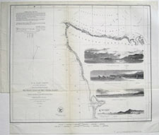
(click to enlarge)
Map Title:
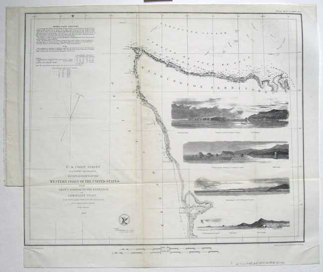
U.S. Coast Survey
Reconnaissance of the
Western coast of the United States
from
Gray's Harbor to the entrance
of Admiralty Inlet
[With 4 vignette engraved views: 1) Duncan's Rock, Tatoosh I. & Cape Flattery; 2) Flattery Rocks and White Rock; 3) Destruction Island; and 4) Sail Rock and Pt. Grenville]
Year of Publication: 1853
Size: 19 3/4 (from leftmost edge of fly-leaf) x 16 1/2 inches.
Type of print:
Original steel engraving on thin 19th century map/survey paper
Publisher:
U.S. Coast Survey Office
Condition: Good/Very Good, with folds and fly-leaf binding as issued; minor browning along fold lines, per usual; left border trimmed along binding edge below fly-leaf, as issued; minor wrinkles in corners where the map was held in place by mylar corners on foam-core for gallery display; typical fine line engraved details.

(to be shipped folded)
|
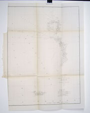
(click to enlarge)
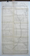
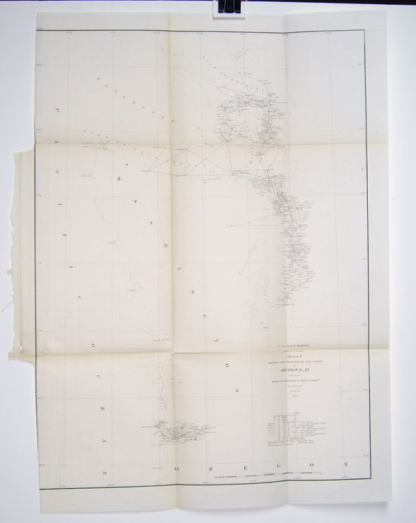
Map Title:
U.S. Coast Survey
Sketch K
Showing the progress of the Survey in
Section No. XI (Upper Sheet)
From Tillamook Bay to the Boundary
from 1850 to 1857
Year of Publication: 1857
Size: 20 1/2 (from leftmost edge of fly-leaf) x 27 inches.
Type of print:
Original steel engraving on thin 19th century map/survey paper
Publisher:
U.S. Coast Survey Office
Condition: Good, with folds and fly-leaf binding as issued; minor browning along fold lines, per usual; one tiny split at a fold intersection; left border trimmed along binding edge above and below fly-leaf; typical fine line engraved details.
(to be shipped folded)
|
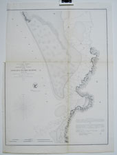
(click to enlarge)
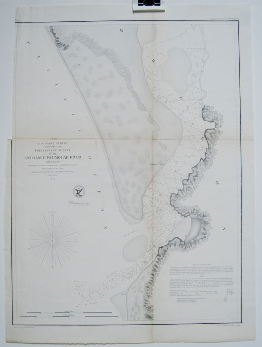
Map Title:
U.S. Coast Survey
Preliminary Survey of the
Entrance to Umquah River
Oregon
Year of Publication: 1854
Size: 14 (from leftmost edge of fly-leaf) x 19 inches.
Type of print:
Original steel engraving on thin 19th century map/survey paper
Publisher:
U.S. Coast Survey Office
Condition: Good, with folds and fly-leaf binding as issued; minor browning along fold lines, per usual; left border trimmed along binding edge above fly-leaf.
(to be shipped folded)
|
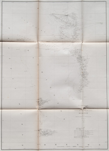
(click to enlarge)
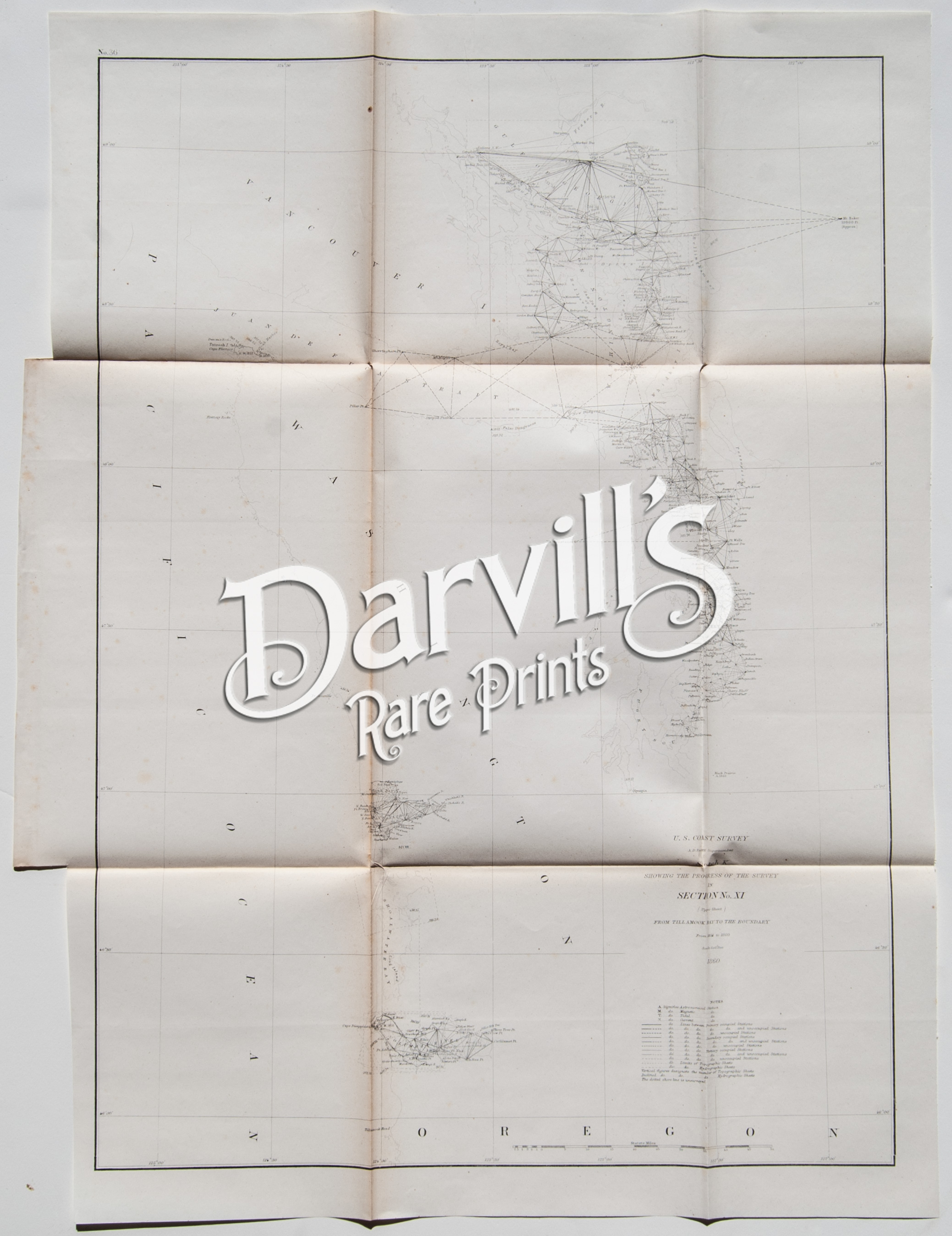
Map Title:
U.S. Coast Survey
from Tillamook Bay to the Boundary
(California, Oregon, Washington, British Columbia)
Year of Publication: 1860
Size: (from leftmost edge of fly-leaf) 20.5 x 27 inches.
Type of print:
Original steel engraving on thin 19th century map/survey paper
Publisher:
U.S. Coast Survey Office
Condition: Very Good/Excellent, with folds and fly-leaf binding as issued; minor browning along fold lines, per usual; minor foxing
(to be shipped folded)
|
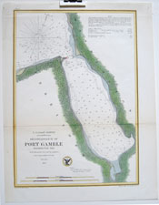
(click to enlarge)
Map Title:
U.S. Coast Survey
Reconnaissance of
Port Gamble
Washington Territory
Year of Publication: 1856
Size: 10 5/8 x 13 7/8 inches.
Type of print:
Engraving, with hand coloring
Publisher:
U.S. Coast Survey Office
Condition: Very Good/Excellent, with lower fold, as issued; binding holes/split at extreme top edge.

|
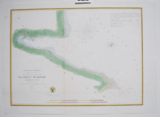
(click to enlarge)
Map Title:
U.S. Coast Survey
Reconnaissance of
Blakely Harbor
Washington Territory
Year of Publication: 1856
Size: 18 1/2 x 13 inches.
Type of print:
Engraving, with hand coloring
Publisher:
U.S. Coast Survey Office
Condition: Very Good/Excellent, with folds, as issued; one fox mark in left margin; lower left margin slightly trimmed, but very ample margin remains.
|
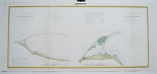
(click to enlarge)
Map Title:
U.S. Coast Survey
Reconnaissance of
False Dungeness Harbor
and
Dungeness Harbor
Washington
Year of Publication: 1856
Size: 24 1/4 x 10 3/4 inches.
Type of print:
Engraving, with hand coloring
Publisher:
U.S. Coast Survey Office
Condition: Very Good/Excellent, with folds, as issued; crimp in lower left margin, not affecting image.
|
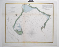
(click to enlarge)
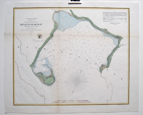
Map Title:
U.S. Coast Survey
Reconnaissance of
Bellingham Bay
Washington Ter.
Year of Publication: 1856
Size: 19 1/4 x 15 1/2 inches.
Type of print:
Engraving, with hand coloring
Publisher:
U.S. Coast Survey Office
Condition: Very Good/Excellent, with folds, as issued; blue watercolor paint spot in upper right, well outside of image area.
|
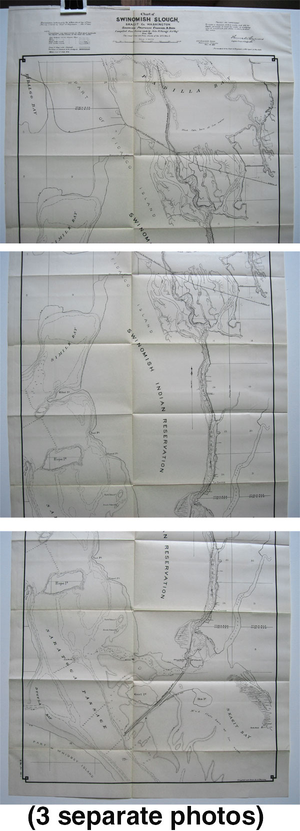
(click to enlarge)
click here for more partial detail photos
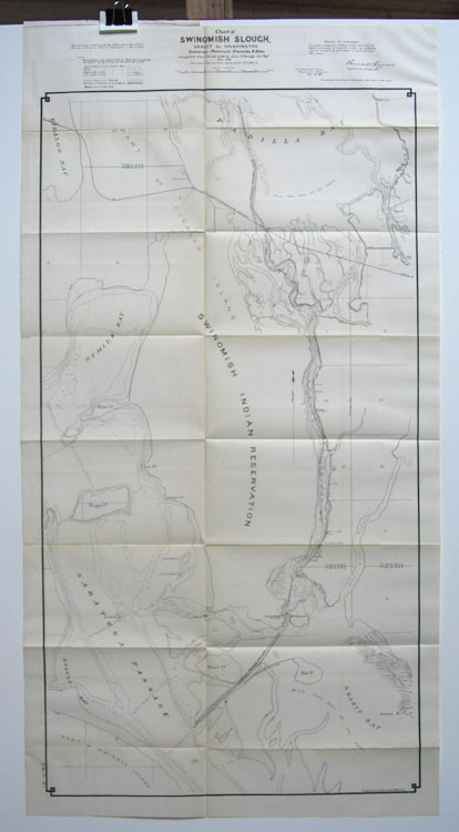
Map Title:
Chart of Swinomish Slough,
Skagit County, Washington
showing proposed Channels and Dikes
[parts of Fidalgo Island, Whidby Island,
Swinomish Indian Reservation, Padilla Bay, etc.]
Year of Publication: 1891
Size: 20 x 38 inches.
Type of print:
Lithograph
Publisher:
U.S. Engineer Office
Condition: Very Good/Excellent, with folds, as issued; light browning and occasional splits along fold lines.
(to be shipped folded)
|

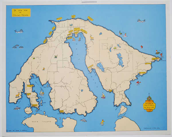
(click to enlarge)
Map Title:
Orcas Island, Bicentennial of its Discovery 1790-1990
Limited edition map by Philo Lund
(this is the last map available from edition of 650)
Year of Publication: 1990
Hand-signed/Numbered by Philo Lund (650/650)
Size: 24 x 19 inches.
Type of print:
Offset Lithograph
Publisher:
Philo Lund
Condition:
Excellent to Very Good
(slight corner damage)
|
(click to enlarge)
Map Title:
Ye Old Map of Orcas Island
[A classic map of Orcas Island published by our founder
Fred T. Darvill. We still have a few maps from the original printing nearly 70 years ago!]
Year of Publication: 1946
Size: 20 x 16 inches
Type of print:
Color lithograph after engraving by F. Stanley Piper
Publisher:
Fred T. Darvill
Condition:
Excellent
|
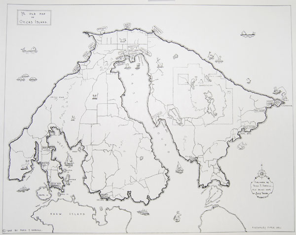
(click to enlarge)
Map Title:
Ye Old Map of Orcas Island
[Same map as to left, but without color. From the original printing run in 1946.]
Year of Publication: 1946
Size: 20 x 16 inches
Type of print:
Lithograph after engraving by F. Stanley Piper
Publisher:
Fred T. Darvill
Condition:
Excellent
|
