RARE AND ANTIQUE MAPS OF GERMANY |
(click image for more information,
and/or to purchase the map ) |
Title / Publisher / Atlas or publication
(Date of publication) Size in inches |
| 
click for details
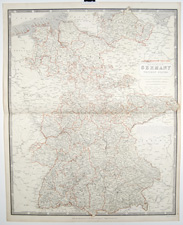
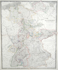
G-26 |
"Germany" (Western States)
Alexander Keith Johnston The National Atlas of Historical, Commercial, and Political Geography...
Edinburgh (1849)
20 1/4 x 25 1/2 inches |
|
| 
click for details
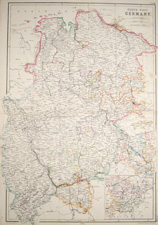
G-27 |
"North West Germany"
Blackie & Son The Imperial Atlas of Modern Geopgraphy...
Glasgow, Edinburgh and London (1860)
15 x 21 1/2 inches |
|
| 
click for details
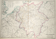
G-28 |
"The German Confederation and Adjacent Countries, showing the Principal Railways of Central Europe"
Blackie & Son The Imperial Atlas of Modern Geopgraphy...
Glasgow, Edinburgh and London (1860)
21 1/2 x 15 inches
|
|
| 
click for details
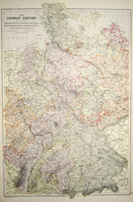
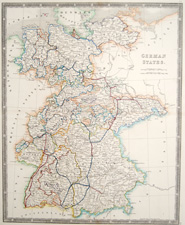
G-29 |
"The German Empire" (West Sheet)
Rhenish, Prussia, Schleswig-Holstein, Mecklenburg, Alsace-Lorraine, Baden, Wuertemburg, Bavaria, etc.
Blackie & Son The Imperial Atlas of Modern Geopgraphy...
Glasgow, Edinburgh and London (1860)
21 1/2 x 15 inches
|
|
| 
click for details
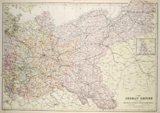
G-30 |
"The German Empire" (East Sheet)
Prussia, Saxony, Mecklenburg, etc.
Blackie & Son The Imperial Atlas of Modern Geopgraphy...
Glasgow, Edinburgh and London (1860)
21 1/2 x 15 inches
|
|
| 
click for details
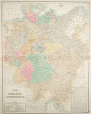
G-31 |
"States of the Germanic Confederation"
Archibald Fullarton Fullarton's Royal Illustrated Atlas
Edinburgh, London & Dublin (1854-1862)
18 1/2 x 23 inches
|
|
| 
click for details
G-32 |
"Germany" (Western States)
Alexander Keith Johnston The National Atlas of Historical, Commercial, and Political Geography...
London, Dublin & Edinburgh (1850)
21 x 25 1/2 inches
|
|
| 
click for details
G-33 |
"German States"
Henry Teesdale New General Atlas
London, (1831)
15 1/2 x 18 3/4 inches
|
|
| 
click for details
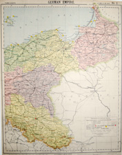
G-34 |
"German Empire" (Northeast part)
Letts, Son & Co. Limited • Letts's Popular Atlas
London, (1884-85)
12 3/4 x 16 1/2 inches
|
|
| 
click for details
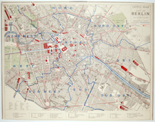
G-35 |
"City of Berlin"
Letts, Son & Co. Limited • Letts's Popular Atlas
London, (1884-85)
approx. 15 1/4 x 12 inches
|
|
| 
click for details
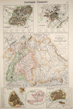
G-36A |
"Southern Germany" (states of Bavaria, Wurtemburg, Baden, Nassau, Darmstadt, Coburg, etc.) and city maps of Nuremberg, Munich, Mayence, and Frankfort [sic]
Archibald Fullarton
The Royal Illustrated Atlas of Modern Geography
London & Edinburgh (1854-1862)
12 3/4 x 19 inches
|
|
| 
click for details
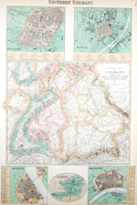
G-36B |
"Southern Germany" (states of Bavaria, Wurtemburg, Baden, Nassau, Darmstadt, Coburg, etc.) and city maps of Nuremberg, Munich, Mayence, and Frankfort [sic]
Archibald Fullarton
The Royal Illustrated Atlas of Modern Geography
London & Edinburgh (1854-1862)
12 3/4 x 19 inches
|
|
| 
click for details
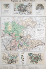
G-37A |
"Northern and Central Germany" with City Maps of Coblentz, Hamburg, Cologne, Dresden, and Leipsic [sic]
Archibald Fullarton
The Royal Illustrated Atlas of Modern Geography
London & Edinburgh (1854-1862)
12 3/4 x 19 inches
|
|
| 
click for details
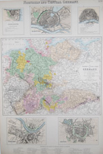
G-37B |
"Northern and Central Germany" with City Maps of Coblentz, Hamburg, Cologne, Dresden, and Leipsic [sic]
Archibald Fullarton
The Royal Illustrated Atlas of Modern Geography
London & Edinburgh (1854-1862)
12 3/4 x 19 inches
|
|